


Last updated: September 2026
Google Earth Pro is Google’s free desktop application for exploring satellite and aerial imagery, 3D terrain, 3D buildings, Street View, historical imagery, geographic data, GPS tracks, measurements, and custom mapping projects.
Unlike Google Maps, which focuses heavily on navigation and everyday location searches, Google Earth Pro is designed for deeper geographic exploration, visualization, data import, mapping, and desktop workflows.
Google currently lists Google Earth Pro 7.3.7 as the latest desktop release. However, Google has announced that new downloads of Google Earth Pro for desktop will no longer be available beginning June 25, 2027. Existing users and people who download it before that date can continue using the desktop application afterward. Google is encouraging users to increasingly use Google Earth on the web and mobile.
Google Earth Pro at a Glance
| Feature | Google Earth Pro |
|---|---|
| Desktop application | Yes |
| Cost | Free |
| Windows | Yes |
| macOS | Yes |
| Linux | Yes |
| Satellite and aerial imagery | Yes |
| 3D terrain | Yes |
| 3D buildings | Yes |
| Street View | Yes |
| Historical imagery | Yes |
| Distance and area measurements | Yes |
| 3D measurements | Yes |
| GPS data | Yes |
| KML/KMZ | Yes |
| CSV import | Yes |
| GeoJSON import | Yes |
| Shapefile workflows | Yes |
| GeoTIFF | Yes |
| Image overlays | Yes |
| High-resolution image export | Yes |
| Tours | Yes |
| Movie Maker | Yes |
| New desktop downloads after June 25, 2027 | No |
Google’s official documentation currently lists Google Earth Pro 7.3.7 for Windows, Mac, and supported Linux distributions.
What Is Google Earth Pro?
Google Earth Pro is a free desktop application for exploring the world through satellite imagery, aerial photography, 3D terrain, buildings, Street View, and historical imagery.
It also includes tools for:
- Measuring distances and areas
- Creating placemarks, paths, and polygons
- Importing GPS, CSV, KML, KMZ, and GeoJSON data
- Working with selected GIS formats
- Creating image overlays, maps, tours, and geographic videos
Google Earth Pro is useful for education, research, travel planning, property research, presentations, and geographic visualization.
However, it is mainly a visualization and mapping tool. It should not replace professional GIS software, surveying tools, or engineering systems when high accuracy or advanced spatial analysis is required.
Who Is Google Earth Pro For?
Google Earth Pro is useful for a wide range of users, especially those who need desktop-based geographic visualization.
It can be a good fit for:
- Students and teachers studying geography or history
- Researchers comparing locations over time
- Travelers planning routes and exploring destinations
- Journalists researching places and geographic changes
- Businesses conducting preliminary location research
- Property professionals reviewing surrounding areas
- GIS users who need quick visualization of geographic data
- Presenters creating geographic maps, tours, and videos
Google Earth Pro may not be the best choice if you need advanced spatial analysis, professional surveying, complex geoprocessing, spatial databases, or authoritative cadastral data. In those cases, dedicated GIS or surveying tools are more appropriate.
Is Google Earth Pro Free?
Yes. Google Earth Pro is free to use.
Google provides desktop installers for supported Windows, macOS, and Linux systems. The current official documentation lists version 7.3.7.
The word “free” should not be confused with unrestricted use of all Google Earth imagery. Google has separate rules governing attribution, commercial use, and publication of Google Earth content.
If you plan to use Google Earth imagery on a commercial website, advertisement, property listing, promotional page, or other commercial material, check Google’s current Geo Guidelines before publishing it.
What Is the Latest Version of Google Earth Pro?
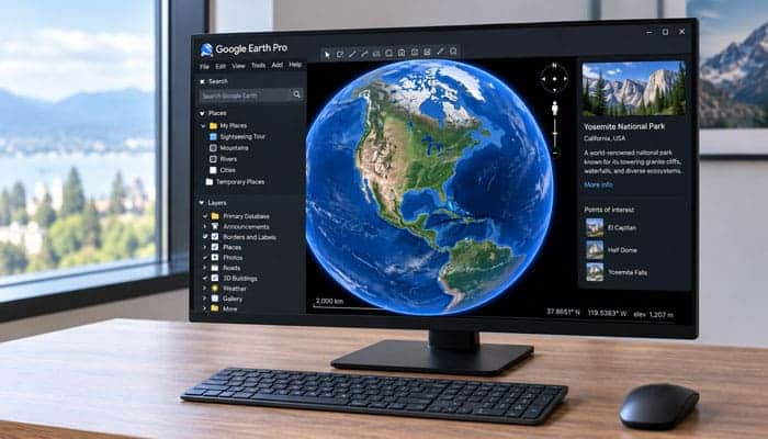
At the time this article was last reviewed, Google lists Google Earth Pro 7.3.7 as the current desktop release.
The 7.3.7 release includes several improvements, including:
- Better compatibility with KML exported from Google Earth 10
- Support for additional KML extensions
- More consistent measurement units
- Ability to save GeoTIFF imports and super overlays as KMZ files that can be opened in Google Earth 10
- Linux launch fixes
- Other bug fixes and improvements
Google’s release notes also document important additions in the preceding 7.3.6 release, including GeoJSON import, improved Movie Maker functionality, HEVC/H.265 support, improved printing, PNG support for Save Image, and other improvements.
Because software versions change, avoid putting a version number in the article title unless you plan to update it regularly. Keep the version number inside the article and update it when Google releases a newer version.
Google Earth Pro Download: How to Get It Safely
The safest way to download Google Earth Pro is from Google’s official Earth documentation rather than an unofficial software-download website.
Google currently provides installers for:
- Windows 32-bit
- Windows 64-bit
- Mac
- Linux Debian/Ubuntu 64-bit
- Linux Fedora/openSUSE 64-bit
Google’s official download documentation currently provides version 7.3.7 direct installers for these supported platforms.
Recommended Download Workflow
- Open Google’s official Google Earth Pro download page.
- Choose the installer for your operating system.
- Download the installation package.
- Run the installer.
- Follow the setup instructions.
- Launch Google Earth Pro.
Is Google Earth Pro Safe to Download?
Yes, when downloaded from Google’s official website.
Avoid unofficial download sites that may provide outdated or modified installers. Before installing, verify that you are obtaining Google Earth Pro from Google’s official distribution channel.
If you already have Google Earth Pro installed, you do not need to download it again simply because the desktop version is scheduled to stop accepting new downloads in 2027.
Avoid Unofficial Download Sites
Third-party download websites can distribute outdated or modified installers. For software that connects to online geographic services, using the official Google distribution channel is the safer choice.
Google Earth Pro System Requirements
Google’s support documentation provides minimum and recommended specifications for the desktop application.
For Windows, Google’s documented minimum requirements include:
- Windows 7 or later
- 1 GHz or faster CPU
- 2 GB RAM
- 2 GB available storage
- Internet connection
- DirectX 9 or OpenGL 1.4-compatible graphics
Google’s recommended Windows configuration includes:
- Windows 7 or later
- 2 GHz dual-core CPU or faster
- 4 GB RAM
- 4 GB available storage
- High-speed internet
- DirectX 11 or OpenGL 2.0-compatible graphics
Google also documents minimum and recommended configurations for Mac and Linux.
These specifications are useful baselines, but real-world performance can vary considerably.
Large KML files, extensive geographic datasets, 3D visualization, image overlays, and video recording can require substantially more system resources.
Google Earth Pro vs. Google Earth: What’s the Difference?
One of the most common search intents around Google Earth Pro is understanding how it differs from regular Google Earth.
| Feature | Google Earth Pro Desktop | Google Earth Web |
|---|---|---|
| 3D globe | Yes | Yes |
| Satellite imagery | Yes | Yes |
| 3D terrain | Yes | Yes |
| 3D buildings | Yes | Yes |
| Street View | Yes | Yes |
| Historical imagery | Yes | Yes |
| Measurements | Yes | Yes |
| KML/KMZ workflows | Strong | Yes |
| GPS workflows | Yes | Different workflow |
| CSV/GIS workflows | Strong | Increasing |
| Desktop file management | Yes | No |
| Movie Maker | Yes | No equivalent desktop workflow |
| Image overlays | Yes | Different workflow |
| Browser-based | No | Yes |
| Mobile | No | Yes |
Google says Google Earth on the web includes many popular desktop capabilities while adding newer features such as historical Street View, advanced measurement, environmental data, project sharing and editing, AI-powered capabilities, shapefile import, elevation profiles, and other updates.
Which Should You Use?
Choose Google Earth Pro when you need a desktop application and its specialized file, GPS, mapping, measurement, overlay, printing, or Movie Maker workflows.
Choose Google Earth on the web when you prefer browser-based access and Google’s newer online features.
For long-term projects, learning both is increasingly useful.
Google Earth Pro vs Google Maps
Google Earth Pro and Google Maps serve different primary purposes.
| Feature | Google Earth Pro | Google Maps |
|---|---|---|
| 3D globe exploration | Excellent | Limited |
| Historical imagery | Yes | Limited/different experience |
| Turn-by-turn navigation | No | Yes |
| Directions | Limited | Excellent |
| Street View | Yes | Yes |
| KML/KMZ workflows | Strong | Limited |
| GPS/GIS workflows | Stronger | More limited |
| Business discovery | Limited | Excellent |
| Route planning | Good for visualization | Excellent for navigation |
| Desktop geographic projects | Yes | No equivalent workflow |
Which Should You Use?
Use Google Earth Pro for geographic exploration, historical imagery, 3D visualization, GIS-oriented workflows, KML/KMZ projects, measurements, and desktop mapping.
Use Google Maps for navigation, directions, traffic, local businesses, and everyday location searches.
Google Earth Pro Features
1. Satellite and Aerial Imagery
Satellite and aerial imagery are core features of Google Earth Pro. You can explore cities, roads, buildings, farms, forests, coastlines, rivers, airports, mountains, and rural areas.
Google Earth imagery is not guaranteed to be real-time. Availability depends on the location, source, collection date, and Google’s updates.
Is Google Earth Pro Live?
No. Google Earth Pro does not provide guaranteed live satellite imagery. Check imagery dates if recent conditions are important.
2. Historical Imagery
Historical imagery lets you compare locations across different dates and study changes such as:
- Urban development
- Construction
- Road changes
- Agriculture
- Deforestation
- Infrastructure
- Coastline changes
- Land-use changes
How to Use Historical Imagery
- Open Google Earth Pro.
- Search for a location.
- Zoom into the area.
- Select the historical imagery tool.
- Choose an available date from the timeline.
- Compare the imagery.
Historical coverage varies by location, and displayed dates may not represent the exact capture date of every part of an image.
3. 3D Buildings and Terrain
Google Earth Pro can display 3D terrain and buildings in supported locations.
You can tilt and rotate the globe, explore skylines, examine mountains and valleys, and inspect terrain.
This is useful for education, architecture, urban studies, travel planning, site visualization, and presentations.
3D coverage is not available equally everywhere.
4. Street View
Street View provides ground-level views in supported locations.
It can help with:
- Travel planning
- Neighborhood research
- Road exploration
- Education
- Location research
Google states that Google Earth Pro 7.3.3 or newer is required for Street View access.
5. Measure Distance and Area
The Ruler tool can measure:
- Lines
- Paths
- Polygons
- Circles
- 3D paths
- 3D polygons
How to Measure Distance
- Open Google Earth Pro.
- Navigate to a location.
- Select Tools → Ruler.
- Choose a measurement type.
- Mark the required points.
- Review the result.
Can Google Earth Pro Measure Land Area?
Yes. Draw a polygon around an area to calculate an approximate area.
However, these measurements should not replace professional surveying for legal boundaries, construction, engineering, or land disputes.
6. Elevation Profiles
Elevation profiles show how elevation changes along a path or track.
They can be useful for hiking, cycling, terrain studies, education, and GPS analysis.
7. Create Placemarks
Placemarks let you save specific locations such as:
- Research sites
- Tourist attractions
- Businesses
- Buildings
- Project locations
- Historical sites
You can customize the name, description, icon, position, and appearance.
Using descriptive names such as North Entrance — Research Area makes projects easier to manage.
8. Draw Paths and Lines
The Path tool lets you create lines for:
- Hiking routes
- Road trips
- Proposed routes
- Research tracks
- Geographic boundaries
Paths can be measured, styled, organized, and exported.
9. Draw Polygons
Polygons let you outline areas such as parks, farms, lakes, neighborhoods, and study areas.
You can also calculate approximate area measurements.
However, polygons created in Google Earth Pro should not be treated as official property boundaries.
10. Import CSV Data
Google Earth Pro can import location data from CSV files.
| Site | Latitude | Longitude |
|---|---|---|
| Site A | 12.9716 | 77.5946 |
| Site B | 17.3850 | 78.4867 |
| Site C | 13.0827 | 80.2707 |
CSV files containing latitude and longitude can be converted into geographic placemarks.
CSV Import Workflow
- Prepare the CSV file.
- Select File → Import.
- Choose the CSV file.
- Identify the latitude and longitude fields.
- Complete the import.
- Apply styling if needed.
CSV imports are useful for business locations, customer data, research observations, field sites, and geographic datasets.
11. Import GIS Data
Google Earth Pro supports several geographic formats, including:
- ESRI Shapefile
- MapInfo TAB
- GeoTIFF
- TIFF
- GeoJSON
- CSV
GeoJSON support makes it easier to move data between web mapping, GIS tools, and Google Earth.
Shapefile Warning
Shapefiles may require supporting files. Projection or coordinate-system problems can also cause data to appear in the wrong location.
Google Earth Pro Is Not Full GIS Software
Google Earth Pro is excellent for visualization, but advanced spatial analysis, geoprocessing, spatial databases, and professional cartography may require dedicated GIS software.
12. Import GPS Data
Google Earth Pro supports GPS tracks, waypoints, and routes.
This can be useful for:
- Hiking
- Cycling
- Road trips
- Fieldwork
- Outdoor activities
- Geographic research
13. KML and KMZ Files
KML stands for Keyhole Markup Language. It stores geographic information such as placemarks, paths, polygons, styles, descriptions, and overlays.
KMZ is a compressed or packaged form of KML.
Why KML and KMZ Matter
These formats make Google Earth projects easier to save, organize, and share.
Google Earth Pro 7.3.7 also improved compatibility with KML exported from Google Earth 10.
14. GeoJSON Support
GeoJSON is commonly used in web mapping.
Google Earth Pro can import GeoJSON data, making it easier to transfer geographic information between:
- Web mapping applications
- GIS tools
- Data-analysis tools
- Google Earth projects
15. Image Overlays
Image overlays let you place external images over geographic terrain.
They can be used for:
- Historical maps
- Planning drawings
- Research maps
- Site plans
- Geographic comparisons
You can reposition, resize, rotate, and adjust the transparency of an overlay.
16. Save High-Resolution Images
Google Earth Pro includes a Save Image tool for creating map images.
You can include elements such as:
- Titles
- Descriptions
- Legends
- Labels
- Map information
Google Earth Pro 7.3.6 increased the maximum Save Image size and added PNG support.
Publishing Warning
Saving an image does not automatically give you unrestricted publishing rights. Check Google’s current licensing and attribution rules before commercial use.
17. Print Maps
Google Earth Pro supports map printing with elements such as:
- Scale
- North indicator
- Legend
- Map information
This is useful for classrooms, reports, presentations, and research.
18. Create Tours
Tours let you move between locations in a controlled sequence.
They can be useful for education, presentations, travel storytelling, research, and property visualization.
For example:
World → Country → City → Neighborhood → Landmark
19. Google Earth Pro Movie Maker
Movie Maker allows you to record geographic navigation and presentations.
Google Earth Pro 7.3.6 added improvements such as:
- Hardware-accelerated video encoding
- HEVC/H.265 support
- Better recording performance
- Historical imagery controls
- Street View controls
- Deferred video encoding
For example, a teacher could record a journey from a global view to a city, show 3D terrain, compare historical imagery, and finish at a landmark.
20. Time-Based Geographic Data
Google Earth Pro can display geographic information connected to time.
This can help visualize:
- Movement
- Journeys
- Historical changes
- Geographic events
- GPS activity
The time slider lets you explore available data across different periods.
How to Use Google Earth Pro: Beginner’s Guide
If you’re new to the software, start with these steps.
Step 1: Open Google Earth Pro
Launch the desktop application.
Step 2: Search for a Location
Enter an address, city, landmark, business, or coordinate.
Step 3: Explore the Area
Zoom, pan, rotate, and tilt the globe.
Step 4: Enable Useful Layers
Turn on relevant geographic layers.
Step 5: Explore 3D
Tilt the view to inspect terrain and buildings.
Step 6: Try Street View
Use Street View where coverage is available.
Step 7: Check Historical Imagery
Compare available imagery from different dates.
Step 8: Measure Something
Use the Ruler tool to calculate a distance or area.
Step 9: Add a Placemark
Save an important location.
Step 10: Organize Your Places
Create folders for different projects.
Step 11: Save the Project
Export important work as KML or KMZ.
This workflow gives beginners a practical introduction without requiring them to learn every advanced feature immediately.
How to Use Google Earth Pro for Research
A useful research workflow is:
Research question → Location → Current imagery → Historical imagery → Measurements → Data import → Documentation → Export
For example, suppose you are researching urban expansion.
You could:
- Define the study area.
- Examine current imagery.
- Review historical imagery.
- Compare several dates.
- Mark important locations.
- Draw an approximate study boundary.
- Measure distances or areas.
- Import supporting geographic data.
- Save the project.
- Document imagery dates and sources.
How to Use Google Earth Pro for Education
Google Earth Pro can turn geographic concepts into interactive exercises.
Teachers can use it for:
- Geography lessons
- Historical comparisons
- Map-reading activities
- Terrain studies
- Urbanization projects
- Distance calculations
- Virtual field trips
- Environmental research
Students can create their own placemarks, paths, polygons, and tours and explain what each location represents.
How to Use Google Earth Pro for Property Research
Google Earth Pro can help with preliminary visual research around a property.
You can inspect:
- Nearby roads
- Buildings
- Terrain
- Surrounding development
- Historical imagery
- Approximate distances
- Geographic features
But Google Earth Pro should not be treated as a legal land-surveying system.
A line visible in imagery does not necessarily represent an official property boundary.
For transactions, construction, engineering, legal disputes, or formal boundary determination, use authoritative records and qualified professionals.
How to Use Google Earth Pro for Historical Research
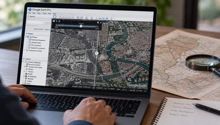
Historical imagery can reveal visible changes in an area over time.
For example:
2008 → 2012 → 2017 → 2022 → Latest available imagery
You might compare:
- Building construction
- Road networks
- Vegetation
- Agricultural land
- Infrastructure
- Urban expansion
Do not assume that imagery exists for every year. Coverage varies by location.
Google Earth Pro File Formats
| Format | Common use |
|---|---|
| KML | Geographic features and projects |
| KMZ | Packaged KML projects |
| CSV | Coordinate-based datasets |
| GPX | GPS tracks and routes |
| LOC | Location/GPS data |
| SHP | GIS vector data |
| TAB | MapInfo geographic data |
| GeoJSON | Web-oriented geographic data |
| GeoTIFF | Georeferenced imagery |
| TIFF | Raster imagery |
| PNG/JPG | Images and overlays |
The exact capabilities and requirements depend on the format and Google Earth Pro version.
Google Earth Pro vs. Professional GIS Software
Google Earth Pro and professional GIS software overlap in some areas, but they are designed for different purposes.
| Google Earth Pro | Professional GIS |
|---|---|
| Easier to learn | Steeper learning curve |
| Excellent globe visualization | Advanced spatial analysis |
| Strong imagery exploration | Advanced geoprocessing |
| KML/KMZ focused | Broad GIS database workflows |
| Basic-to-intermediate measurements | Advanced spatial calculations |
| Good GPS visualization | Advanced geographic analysis |
| Strong presentation capabilities | Professional cartography |
| Free | Licensing varies |
Which Is Better?
It depends on the task.
Use Google Earth Pro for exploration, visualization, presentations, historical imagery, basic measurement, and accessible geographic projects.
Use dedicated GIS software when you need advanced spatial analysis, geoprocessing, spatial databases, or professional cartographic workflows.
Google Earth Pro Accuracy: What You Should Know
A common misconception is that Google Earth Pro measurements are automatically survey-grade.
They are not.
Accuracy can be affected by:
- Imagery quality
- Resolution
- Terrain
- Camera perspective
- Available elevation data
- Coordinate information
- Data age
- Location-specific coverage
For casual planning and geographic visualization, the tools can be extremely useful.
For legally or technically critical measurements, use authoritative data and professional surveying methods.
Is Google Earth Pro Real-Time?
No.
Google Earth Pro does not provide guaranteed live satellite imagery.
A location that looks current may actually be represented by imagery collected earlier.
If recent conditions matter, verify the imagery date and consult an appropriate current source.
Google Earth Pro Copyright and Commercial-Use Rules
This is especially important for bloggers, publishers, businesses, and marketers.
Google Earth Pro being free does not mean Google Earth imagery is free for unrestricted commercial use.
Google’s Geo Guidelines specify attribution requirements and place restrictions on commercial and promotional use of Google Earth content.
Before publishing Google Earth imagery, check Google’s current rules for your specific use case.
Pay Particular Attention If You Want to Use Imagery In:
- Commercial websites
- Advertising
- Promotional campaigns
- Property listings
- Company profiles
- Product marketing
- Website headers
- Commercial videos
Do not simply remove Google’s attribution from a screenshot.
Best Practice
When publishing Google Earth content:
- Check Google’s current Geo Guidelines.
- Keep required attribution visible.
- Do not crop out required credits.
- Check third-party data-provider attribution.
- Confirm that your intended use is permitted.
For commercial projects, investigate appropriate licensing options instead of assuming a Google Earth screenshot is automatically reusable.
Common Google Earth Pro Problems and Fixes
Google Earth Pro Is Slow
Try:
- Closing unnecessary apps
- Reducing visible layers and data
- Splitting large projects
- Updating graphics drivers
- Checking your internet connection
Large KML files and complex 3D views can slow performance.
Google Earth Pro Cannot Connect
Check:
- Internet connection
- Firewall or security software
- Network restrictions
- Proxy settings
Firewall or security tools may block Google Earth Pro from connecting.
Imported Data Is in the Wrong Location
Check:
- Latitude and longitude order
- Coordinate system
- Projection
- CSV formatting
- Required GIS files
3D Buildings Do Not Appear
Try:
- Enabling the 3D Buildings layer
- Restarting Google Earth Pro
- Updating graphics drivers
- Checking graphics compatibility
Google Earth Pro Tips and Tricks
- Organize locations into folders for each project.
- Use clear names instead of labels like “Point 1.”
- Save important projects as KML or KMZ files.
- Keep backup copies of important files.
- Check imagery dates before using them.
- Compare multiple historical images when studying changes.
- Record measurements, sources, dates, and assumptions for research.
- Remove unnecessary layers and temporary data to keep projects running smoothly.
Google Earth Pro for Businesses: What It Can and Cannot Do
Google Earth Pro can support business workflows such as:
- Preliminary site research
- Location presentations
- Geographic visualization
- Route visualization
- Property context
- Market-area presentations
- Infrastructure visualization
However, it should not automatically be treated as:
- A property-survey system
- A legal boundary database
- A construction-grade measurement tool
- A full GIS platform
- A real-time satellite monitoring system
For business decisions involving significant financial, engineering, legal, or safety consequences, verify Google Earth observations against authoritative sources.
What Happens to Google Earth Pro After June 25, 2027?
Google announced that new downloads of Google Earth Pro for desktop will end on June 25, 2027.
This does not mean existing installations will stop working. Users who already have Google Earth Pro, or download it before the cutoff, can continue using the desktop app.
What Is Changing?
New desktop downloads will no longer be available after June 25, 2027.
What Is Not Changing Immediately?
Existing users can continue using Google Earth Pro after the download cutoff.
Where Is Google Heading?
Google is encouraging users to move toward Google Earth on the web and mobile.
The web version continues to gain features such as:
- Historical Street View
- Advanced measurements
- Environmental data
- Project sharing and editing
- AI-powered features
- Shapefile import
- Elevation profiles
Should You Download Google Earth Pro Before 2027?
If you rely on the desktop version, downloading it before June 25, 2027 is a good idea.
This is especially useful for workflows involving:
- KML/KMZ files
- GPS and CSV imports
- GeoJSON
- GIS visualization
- Image overlays
- Movie Maker
- Desktop Places
- Measurement tools
You should also back up important geographic files and become familiar with Google Earth on the web.
How to Prepare for the Google Earth Pro Transition
If you depend on Google Earth Pro:
- Back up KML and KMZ files.
- Organize and clean up My Places.
- Test Google Earth on the web.
- Check important projects in newer Earth environments.
- Document your workflow.
- Consider GIS software for advanced spatial analysis.
Is Google Earth Pro Still Worth Using in 2026?
Yes. Google Earth Pro is still useful for:
- Historical imagery
- 3D terrain and buildings
- Street View
- Distance and area measurements
- GPS data
- KML/KMZ and CSV files
- GeoJSON and GIS visualization
- Image overlays
- Map printing
- Tours
- Movie Maker
The main concern is the future of the desktop app. Google is ending new downloads in 2027 while continuing to develop Google Earth on the web and mobile.
Google Earth Pro: Pros and Cons
| Pros | Cons |
|---|---|
| Free desktop application | Desktop downloads end in 2027 |
| Excellent geographic visualization | Not a full GIS platform |
| Historical imagery | Imagery is not necessarily current |
| 3D terrain and buildings | Coverage varies by location |
| GPS support | Large projects can affect performance |
| KML/KMZ support | Measurements are not survey-grade |
| CSV and GIS workflows | Commercial image use has restrictions |
| GeoJSON support | Some newer features are web-first |
| Image overlays | Requires learning the interface |
| Movie Maker | Long-term desktop direction is changing |
Google Earth Pro Alternatives
Google Earth Pro is not the only option for geographic visualization.
Popular alternatives include:
- Google Earth Web: Best for browser-based exploration and newer Earth features.
- Google Maps: Best for navigation, directions, and business searches.
- QGIS: Best for free, advanced GIS analysis.
- ArcGIS: Best for professional GIS, mapping, and spatial analysis.
Best Practices for Using Google Earth Pro
- Check imagery dates before relying on them.
- Treat measurements as estimates.
- Save original KML, KMZ, CSV, GPS, and GIS files.
- Record sources, dates, coordinate systems, and assumptions.
- Follow Google’s attribution and licensing rules.
- Keep backups of important projects.
- Use dedicated GIS software when advanced analysis is required.
Google Earth Pro FAQs
1. What Is Google Earth Pro?
Google Earth Pro is a free desktop application for exploring satellite imagery, 3D terrain, buildings, Street View, historical imagery, measurements, GPS data, and geographic projects.
2. Is Google Earth Pro Free?
Yes. Google Earth Pro is currently free to download and use.
3. Can Google Earth Pro Show Historical Imagery?
Yes. Google Earth Pro lets you view available imagery from different dates to see how a location has changed over time.
4. Can Google Earth Pro Measure Land Area?
Yes. You can draw polygons around an area and calculate approximate distances and areas using the measurement tools.
5. Can Google Earth Pro Import CSV and GeoJSON Files?
Yes. Google Earth Pro supports CSV and GeoJSON imports, making it useful for visualizing geographic datasets and coordinates.
6. Is Google Earth Pro Accurate for Property Boundaries?
No. Google Earth Pro can help with preliminary property research, but it should not replace official property records or a professional land survey.
7. Can Google Earth Pro Be Used Offline?
Google Earth Pro requires an internet connection for most imagery and online geographic data. Some previously loaded or saved information may remain accessible locally.
8. Is Google Earth Pro Being Discontinued?
New downloads of Google Earth Pro for desktop are scheduled to end on June 25, 2027. Existing users and people who download it before that date can continue using the desktop application afterward.
Final Thoughts: Is Google Earth Pro Worth Using?
Yes. Google Earth Pro remains a useful free desktop mapping and geographic-visualization tool in 2026.
It offers satellite and aerial imagery, historical imagery, 3D terrain and buildings, Street View, measurements, GPS support, KML/KMZ, CSV and GeoJSON imports, image overlays, map exports, tours, and Movie Maker.
It is useful for students, teachers, researchers, travelers, and professionals who need geographic visualization or preliminary location research.
However, Google Earth imagery is not always current, and its measurements should not replace professional surveying. New desktop downloads are also scheduled to end on June 25, 2027, although existing users can continue using the application.
Overall, Google Earth Pro is still worth using for historical imagery, 3D exploration, measurements, GPS, and desktop mapping. For long-term use, it is also smart to learn Google Earth on the web and keep backups of important geographic files.